Solo Backpacking on Mt Passaconaway – 3 Days of Camping in New Hampshire

Join me for 3 Days Ultralight Backpacking on Mt Passaconaway, deep in the Wilderness of New Hampshire’s White Mountains.

Join me for 3 Days Ultralight Backpacking on Mt Passaconaway in the White Mountains, deep in the wilderness of New Hampshire.

FTC Disclosure: This post contains affiliate links, which means I may receive a commission for purchases made through some of my links.

For this 3 day, 2 night backpacking trip, I decided to spend a few days exploring Mt Passaconaway, a 4,000 footer nestled in the Sandwich Range Wilderness of of New Hampshire.

My plan for this trip wasn’t to crush miles, but to instead slow things down and really have a chance to get an intimate look at a smaller area, something I often don’t always do. With it’s combination of a hardwood populated rolling lowland approach hugging the beautiful Oliverian Brook at 1,200′ elevation, followed by a short, but steep rocky ascent up to the ridges leading to the summit of Mt Passaconaway at 4,043 feet, it seemed like the perfect choice for such a trip.

I would spend my first day looking for a suitable break in the dense foliage to camp along the babbling sounds of Oliverian Brook for the night. On day two I would head up towards the summit in search of a clearing just short of the summit to the previous sight of an old lean-to shelter called Camp Rich.  The shelter was removed many years ago, and is no longer listed on newer maps.  According to reports though, there are still some great clearings for camping in the area, which is a rarity at higher elevations in the White Mountains.  Allegedly, there is a rather reliable water source running nearby as well.  Again, a rarity near tree line in the Whites.

My backpack was pretty light for this adventure, consisting of only my trekking pole tent, trekking poles, a single titanium pot with DIY alcohol stove for cooking, a simple foam sleeping pad, 40° down quilt, hardshell jacket, and a mid-layer synthetic hoodie for extra warmth, as the daily low was expected to be in the upper 30’s Fahrenheit. This was pushing it a bit, but I’ve found that the hoodie and hardshell combination works pretty well as a cold weather parka down to around the mid 30’s.  A more detailed list of backpacking gear can be found below.

Despite a temporary minor lower back muscle injury that slowed me down a bit from my normal pace, this ended up being a really fun backpacking trip.  It gave me an opportunity to appreciate the merits of spending more time soaking in a single area at camp or along the trail, rather than hiking triple the miles to hit multiple summits.  While I really enjoy doing hikes like that too, it was pretty awesome to appreciate the character of a single mountain and the random treasures it had to offer.

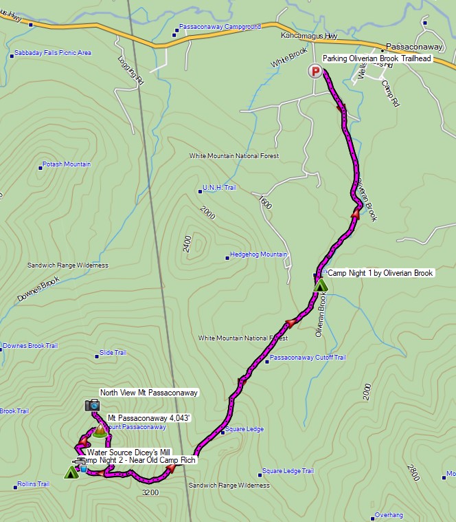
Route Overview White Mountains Mt Passaconaway Backpacking Trip- Sintax77

Continue reading

Ultralight Backpacking on the Carter-Moriah Range

3 Days of Ultralight Backpacking & Hammock Camping on the Carter-Moriah Range in the White Mountains of New Hampshire.

FTC Disclosure: This post contains affiliate links, which means I may receive a commission for purchases made through some of my links.

For this summer backpacking trip, I headed up to the Wild River Wilderness to create a 36 mile hiking loop with 10,000 feet of gross elevation gain by linking together the Appalachian trail with several other lesser used and more rugged trails in the White Mountain National Forest.

My June temperature range for this trip was between 35° and 85° with a chance of rain each day, but mostly during the night.  Due to the wide temp range and the unpredictable weather typically encountered in the White Mountains, I packed in a puffy jacket and some ultralight rain gear for additional protection against the elements.  This brought my pack’s base weight right up to around the 10 lb mark.

  • Thank you to Upstart for sponsoring this trip.  See how they can help you build your credit and get free of high interest debt at Upstart.com/Sintax

I went with my standard minimalist hammock camping setup for this trip.  While I planned to stay at officially recognized campsites, I still wanted the ability to camp at a legal, but unofficial spot if the opportunity or need arose.  Due to the dense vegetation and uneven ground found at upper elevations in the Whites, I’ve learned that a hammock is often the only realistic option in those types of conditions.

Water would be plentiful along the river portion of my loop, but would only be reliably available at Imp campsite during the ridge hike section, so I had to plan accordingly for that during the first half of my trip. The second half of my trip would have more water, but would be on more challenging trails. Notably, the Black Angel Trail, a rugged and minimally maintained wilderness trail, and the Highwater Trail, which suffered substantial washouts and haphazard re-routes due to storm damage from Hurricane Irene back in 2011.

Route Overview – WIld River Carter-Moriah Backpacking Loop – Sintax77

Full GPS track data, including campsites, etc, for this trip and many others can be downloaded on my Trip Data Page.

Continue reading

Winter Camping on Mt Washington – Deep Snow, Below Zero

Backpacking & Winter Camping on the side of Mount Washington.

FTC Disclosure: This post contains affiliate links, which means I may receive a commission for purchases made through some of my links.

For this adventure, I headed back up to the White Mountains of New Hampshire to do some snow camping and make another attempt at doing a Mt Washington winter ascent for some frozen views of the Presidential Range.  I tried this about a year ago, but a stomach bug and 85 MPH winds kind of put a damper on things.  This time around, I also brought a hiking partner, Frank.  We’ve done several winter trips together so far, but this would be his first time in the White Mountains.

Similar to last year’s trip, the plan was to set up a base camp at higher elevation, followed by a lighter weight trek up to the top of Mount Washington if weather conditions and visibility were agreeable. If the conditions were questionable, we made a back-up plan to scurry up the side of the nearer Mt Monroe.  And of course, if the weather really got bad, we would just play it safe and stay below tree line.

Trailhead Used: Ammonoosuc Ravine Trailhead
44°16’01.2″N 71°21’40.7″W
Base Station Rd, Jefferson, NH 03538

This is a large parking lot with room for many vehicles.  A parking fee of $5 dollars per day or an annual National Park pass is required.

Trails Used

  • Ammonoosuc Ravine Trail
  • Appalachian Trail (Crawford Path)
  • Mt Monroe Loop Trail

Campsite

  • Camp along Ammonoosuc Trail 44.26398, -71.32182
    • This was a small unofficial campsite located in a hollowed out spot not too far before entering the Lakes of the Clouds Forest Protection Zone.

Notable Backpacking Gear

Camera and Nav Gear used for this episode

Hammock Camping on the Six Husbands Trail

Hammock Camping and Solo Backpacking in the White Mountains of New Hampshire

FTC Disclosure: This post contains affiliate links, which means I may receive a commission for purchases made through some of my links.

For this adventure, I decided to get back to my ultralight backpacking roots with a rugged 27 mile loop through the Great Gulf Wilderness, Dry River Wilderness, and Presidential Range, with a gross elevation gain of around 8,400 feet. The centerpiece of my loop would be the Six Husbands Trail, a trail that some say is the most difficult in the White Mountain National Forest. Now , if you’re familiar with the WMNF, you probably know that just about every trail is pretty intense, so this could get interesting…

For sleep and shelter, I went with my standard minimalist hammock camping setup consisting of a 10 oz hammock, 5 oz tarp, and a pair of 40° down quilts.  This got my base weight down to around 7 lbs. A full gear list can be found at the bottom of this post.

The Six Husbands Trail was Built from 1909 to 1910 by trail builder Warren W. Hart of the Appalachian Mountain club. Hart was known to build his trails specifically with adventure in mind, and this trail was no exception. It begins deep in the Great Gulf Wilderness at the junction with Wamsutta Trail, which along with the connected Alpine Garden trail is actually just the renamed southern portion of the Six Husbands trail. Wamsutta was one the six husbands of female Indian Chief, Weetamoo, who has a nearby waterfall named after her.

White Mountains Six Husbands Backpacking Loop – Route Overview – Sintax77

Continue reading

Summit Fever – Winter Camping on the Presidential Range

Solo Winter Backpacking & Snow Camping in an attempt to Summit Mount Washington.

FTC Disclosure: This post contains affiliate links, which means I may receive a commission for purchases made through some of my links.

For this adventure, I headed up to the White Mountains of New Hampshire to do some snow camping with the goal of doing of a Mt Washington winter ascent.  My plan was to set up a base camp at higher elevation, followed by a lighter weight trek up to the top of  Mount Washington.

I went with a tent for shelter on this trip because I originally planned for the possibility of camping above treeline.  I had never done that before, but the weather forecast was rather good before I left home, so this seemed like a good opportunity to give it a go.  The Presidential Range had other ideas…

No permit is required to backcountry camp in the White Mountain National Forest, but a parking fee is required in some areas.

Trailhead Used: Jewell Trail Trailhead
44°16’01.2″N 71°21’40.7″W
Base Station Rd, Jefferson, NH 03538

This is a large parking lot with room for many vehicles.  A parking fee of $5 dollars per day or an annual National Park pass is required.

Notable Backpacking Gear

Camera and Nav Gear used for this episode

Winter Camping and Finding a Plane Crash – Mt Success DC-3

Backpacking & Solo Winter Camping in search of a 1954 commercial airline crash near the summit of Mt Success in the White Mountains.

FTC Disclosure: This post contains affiliate links, which means I may receive a commission for purchases made through some of my links.

For this 3 day, 2 night camping trip, I headed up to a lesser traveled corner of New Hampshire’s White Mountain National Forest for some snowshoeing, camp cooking, and bit of New England aviation history.

My goal for this adventure was to find the resting place of Northeast Airlines Flight 792, which crashed on approach to Berlin Municipal Airport during inclement weather on November 30th, 1954. It made contact in the dense trees near the summit of Mt Success at an elevation of 3,390 feet.  More information on the details of Flight 792 and the circumstances of it’s survivors can be found in this copy of the official Accident Investigation Report

The 6.5 mile hike to get there would require a gross elevation gain of roughly 3,700 feet on potentially unbroken trail in deep snow.  The final portion of the hike would be an unofficial bushwhack through dense trees and snow.  For this reason, I chose to break up the approach up by setting up camp at roughly the halfway point along Gentian Pond and the nearby lean-to shelter with sweeping views of the Carter-Moriah mountain range.  After camping for the night, I would head up to the top of Mt Success, the first peak of the Mahoosuc Range and the Appalachian Trail’s gateway to Maine. After a few miles and a couple thousand feet of ascent with my trusty snowshoes, I would leave the trail behind in search of the DC-3.

Mt Success DC-3 Winter Backpacking Trip – Route Overview

No permit is required to backcountry camp in the White Mountains, but some locations do require a daily, weekly, or annual pass.  The parking area for this trip did not require a parking fee as of January 2021.

Full GPS track data, including campsites, water sources, etc, for this trip and many others can be downloaded on my Trip Data Page.

Trailhead Used: Austin Brook Trailhead on North Road,  44°24’45.1″N 71°04’05.4″W
North Rd, Shelburne, NH 03581

Continue reading