Creating a Backpacking Loop for my upcoming winter solo camping trip in Virginia’s Grayson Highlands.
For part three of this series, I’ll be going over my specific route selection for my solo backpacking loop, including trails used, potential parking / starting points, and expected camping areas for each night. The map I chose to purchase for this trip, based on viewer feedback, was National Geographic’s Map #318 for the Mount Rogers High Country Grayson Highlands State Park region of Virginia.
A good portion of this loop will utilizing the Appalachian Trail, within the Mt Rogers National Recreation Area, as well as several other connecting trails within the Lewis Fork Wilderness and Little Wilson Creek Wilderness areas.
I will be doing continued updates throughout the whole process of planning this winter hiking trip. All the way from location selection, specific route planning, packing, food choices, getting there, doing the actual trip, and whatever else may come up in between, so check back for updates!
Join TJ & I for 3 days of hiking, camping & backpacking in New Hampshire’s Great Gulf Wilderness. Oh, & I also fall on my face.
For this adventure, we’ll be revisiting an attempt at a hike that I originally did as a solo backpacking trip a few years back. A rather aggressive loop, chalking up 30+ miles and over 15,000 feet gross elevation gain, the plan was to give it another go while giving TJ an ultimate sampler platter of the White Mountains. As fate would have it, things would corkscrew towards another outcome…
Full GPS track data and waypoints for various POI’s on this trip are available for download on the Trip Data Page.
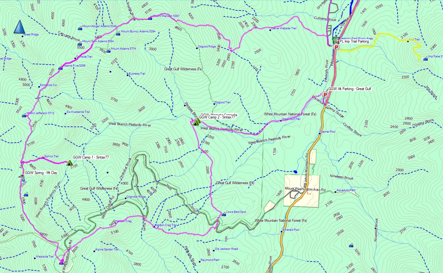
Trails Used, Day 1 (in order)
Road hike north on Rt 16 to Dolly Copp Campground
Daniel Webster Scout Trail
Appalachian Trail South
Sphinx Trail
Camp along Sphinx Trail, just before junction with Great Gulf Trail
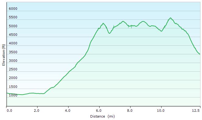
Great Gulf Loop Day 1 Elevation Profile – Sintax77
Day 1 Mileage: 12.5 miles Day 1 Gross Elevation Gain: 6,661′
Trails Used, Day 2 (in order)
Double back on Sphinx Trail
Appalachian Trail South
Trinity Heights Connector to Summit of Mt Washington
Have a Chili Dog at the Summit
Nelson Crag Trail
Appalachian Trail South
Great Gulf Trail
Camp near Gulf Trail along ridge
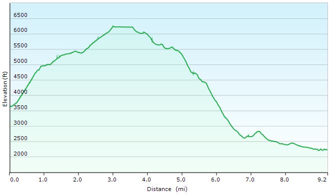
Great Gulf Loop Day 2 Elevation Profile – Sintax77
Day 2 Mileage: 9.2 miles Day 2 Gross Elevation Gain: 3,658′
Trails Used, Day 3 (in order)
Great Gulf Trail
Short road hike back to car parked at Imp Trail Head
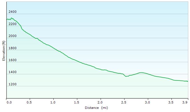
Great Gulf Loop Day 3 Elevation Profile – Sintax77
Day 3 Mileage: 3.9 Day 3 Gross Elevation Gain: 108′
Mileage Grand Total for Trip: 25.6 Gross Elevation Gain Grand Total for Trip: 10,319′
Join Mike and I for for a “Train to Trail” Winter Camping, Backpacking, Campfire cooking, & Hiking adventure in Harpers Ferry, WV.
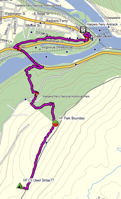
We tried something a bit different for fun on this winter camping trip – instead of driving, we decided to take an Amtrak train directly to the trailhead. This is actually and idea that Mike and I had been kicking around for a while now. The first challenge was finding an interesting trail that was actually close to a train station, without a need for secondary transportation or an excessive walk. After a bit of research, we determined that Harpers Ferry, West Virginia fit the criteria quite well. The train practically dumps you right on the Appalachian Trail. We booked our tickets, packed our bags, and hit the trail, er, I mean, train station.
With 4 days and 3 nights off, we had a decent amount of time to play with on this trip. The challenge however, would be that we needed to plan an out and back trip that didn’t put us to far away from the train station on our final morning, rather than doing a loop like we normally prefer. Fortunately, we quickly realized that to be a perfect excuse to do a a laid back, more camping, less hiking kind of trip.
The plan? After leaving the train behind,we would hop on the Appalachian trail for a few miles – just long enough to feel the seclusion of the deep winter woods, and set up a base camp for the duration of the trip. Other than that, we really had no hard set plans, other than relaxing, having a good time, and brushing up on our campfire cooking skills. Did we succeed? I guess you’ll just have to watch and see…
Trails Used
Leave Harpers Ferry via Appalachian Trail South After around 3 miles, bushwack West to unofficial campsite.
Return via Appalachian Trail North
Join Sara & for some backpacking, hiking and hammock camping along the Appalachian Trail in Virginia’s James River Face Wilderness Area.
For this fall backpacking trip we’ll be dipping into the world of the Appalachian Trail while testing out some new hammock camping gear – most notably, the Amok Draumr 3.0 Hammock system. The Draumr is a rather unique flat hammock that I touched on in a previous blog post and video, ‘Amok Draumr 3.0 – A Super Flat Hammock? – First Look‘. As discussed in that video, the Draumr works in conjunction with an inflatable sleeping pad to create what is essentially a floating bed. It can also be used in a chair configuration for lounging at camp. In addition to testing out the Draumr, I’ll be trying out some whoopie slings rigged up with some Dutch Whoopie Hooks. The hooks allowed for a really quick and simple way to attach and detach the whoopie slings to my trusty Darien Dream Hammock.
With our shelter and sleeping methods squared away, we were ready for some exploration of the east coast’s most fabled long distance hiking path – the Appalachian Trail, the “AT” as it’s affectionately called by those of us who prefer a nice acronym now and the. While I’ve incorporated pieces of the AT into many of my trips before, this particular hike seemed to really capture the spirit and flavor of the Appalachian Trail.
James River Face Wilderness – Route Overview – Sintax77
Along the way, we bumped into and chatted with some friendly southbound Thru-hikers (or “SoBo’s” as they’re commonly called), checked out a classic example of an Appalachian Trail Shelter (Matt’s Creek Shelter), got some great laughs and stories out of the shelter’s trail journal, and got a healthy dose of rolling ridge line views. While it was obviously no comparison to the experience of actually being out on the AT for five to seven months over the course of it’s roughly 2,200 miles, it was a great little 2 day crash course of what life might be like for the some of the 12,000 or so alumni who have hiked the Appalachian Trail since it’s inception back in 1937.
Who knows, maybe some day Sara and I will be among those dedicated hikers as well, but for now, the occasional appetizer version is quite tasty too! Below is are some details on the section that we did. GPS track data, along with waypoints for our campsite and other points of interest are available for download on our Trip Data Page as well.
Trailhead and Parking: James River Footbridge N37° 35.819′ W79° 23.474′
The James River Face Wilderness Area is a protected area located within the Jefferson National Forest, about 1 hour north of Roanoke, Virginia.
Route Taken and Trails Used, Day One
Access the James River Foot Bridge by heading out of parking lot and passing under the railroad trestle. SinFact: This is the longest pedestrian ridge on the entire Appalachian Trail
Leaving the foot bridge, turn left to continue following the AT along the banks of the river for a while.
The trail will eventually turn away from the river and and head deeper into the woods,following along Matt’s Creek.
Arrive at Matt’s Creek Shelter for a snack break at the picnic bench, and an entertaining peek at the shelter log.
Leaving the shelter, head up the ridge to continue on the Appalachian Trail and get some views of James River, flowing below.
5 miles into the hike there will be a decent lunch spot (marked in my GPS data) with a nice, flat sunny area for lounging before ascending further up the the ridge. This spot was also the last flowing water source we encountered for the rest of the day. If you plan to camp up on the ridge in the same area that we did, make sure to stock up on enough water for the rest of the day, as well as tomorrow for breakfast and the hike out, to be safe.
Continue on the AT until arriving at the three way junction with Balcony Falls Trail and Sulphur Springs Trail. This is where we departed the AT and headed down the Sulphur Springs trail in search of a campsite for the night.
Note: Sulphur Springs trail does not appear to be officially maintained and may be quite grown in and harder to navigate in the summer.
Trip variation Option: If you continue on the Appalachian Trail for another half mile you will reach a junction with the Belfast Trail. About a half mile or less down the Belfast Trail is a possible campsite near the intersection with the Gunter Ridge Trail. It’s important to note that I haven’t personally been to this site, so I’m not sure how legit it may be. It’s location is approximated based on comments I’ve seen posted online, combined with topo map data and may not actually be a suitable site. We chose not to venture that way, but from looking at a photo I found online, it looks like a rather flat, alternate site for camping. Approximately a mile beyond Gunter Ridge campsite is the Devil’s Marble yard, a potential side trip that I hear has very nice views. Nearby is another possible site, marked in my GPS data as well.
Continue along the Sulphur Springs trail for a little less than a mile.
Camp at either of the site’s listed in my GPS Data. We chose the smaller spot labeled “JRF CS Night 1” for it’s better views off the ridge for sunset. On the other side of the trail there is also a larger potential camping area labeled “JRF Hickory Stand CS”. This spot lacks the views down the ridge, but is larger and offers potentially better wind protection, depending on conditions.
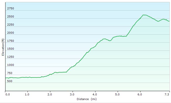
Day 1 Total Mileage: 6.8 Miles Day 1 Total Elevation Gain: 2,297′
Sintax77 – James River Face Wilderness Loop – Day 1 Elevation Profile
Route Taken and Trails Used, Day Two
After packing up camp, you have two options. While it’s possible to continue down the meandering Sulphur Springs Trail for a couple until it runs into the AT, we chose instead to immediately start our day back on our old friend, the AT. This was possible by doing a very small “bushwack” west from the campsite until you run into the adjacent campsite then head south on the AT by turning left. The campsite is literally right smack between the two trails, so the AT should be super easy to spot.
Continue along the AT until you hit the triple junction with Sulphur Springs, the AT and Piney Ridge Trail.
Head down the Piney Ridge Trail, towards Hunt Club Road, which will eventually bring you to Rt 501 Lee Jackson Highway.
Turn left (north) to do a road hike along Lee Jackson Hwy for a short bit, at which point you have two options:
After a mile or so, the Highwater Trailhead (the old AT) will appear on the left side of the road. The sign will actually be for Matt’s Creek, where we were the day before. You can take this trail all the way back to the shelter, then backtrack to the parking lot on the AT, the same way you came in on day one. From trailhead to car looks to be about 4 miles.
We chose to make a more expedient route back to the car, by continuing to walk along the road, over the auto bridge’s pedestrian sidewalk. This route gave us a pretty cool view of the man made waterfall, as well as an alternate view of the rail trestle and footbridge that we had traveled over the previous day.
Arrive back at the Jame River Foot Bridge Parking lot and prepare yourself for cheeseburger time.
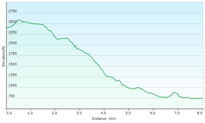
Day 2 Total Mileage: 8 Miles Day 2 Total Elevation Gain: 486′
James River Face Wilderness – Day 2 Elevation Profile – Sintax77
Trip Mileage Grand Total: 14.8 Miles Trip Elevation Gain Grand Total: 2,783′
The new 2016 Spring ‘Go Time Camp’ Cabin Trip video is up now on the Whiterook85 channel and a new feature length hiking video with Sara and I testing the Amok Draumr 3.0 hammock on a section on the Appalachian Trail will be live this Sunday, May 15th at 6 PM EDT.
Join Mike, TJ and I for 4 days of hiking & camping as we initiate our friend Zeke on his very first backpacking trip!
For this backpacking trip, we’ll be visiting one of my favorite areas, the White Mountains, for a counterclockwise Pemi Loop. While I’ve previously done this loop as a solo hike, I switched things up this time by doing the loop in the opposite direction, starting with Bondcliff Trail and the Bonds and ending with a traverse of Franconia Ridge to return to the Lincoln Woods Visitor Center where we started. We also stretched the hike out to 4 days and 3 nights. This enabled us to get some more camping and exploring in, and also let us do less miles per day, since this was our friend’s first backpacking experience. The White Mountains are home to some of the most aggressive hiking trails in the country, and our goal was to make sure he actually wanted to do this again!
If you’ve never done a Pemi Loop before and are looking for some more logistics, trail listings, etc, feel free to check out my previous solo video. For this video, we’ll be focusing more the amazing views, camp camaraderie and of course, the biggest question – will Zeke ever want to do this again? Or will he want to push us off one of the numerous precipices that the Pemigewasset Wilderness has to offer…
For info on the “helicopter situation” click here for a link to an August 28th post the Pemigewasset Valley Search and Rescue Team’s Facebook page.
A note on GPS Data: I didn’t record new GPS track data for this trip, as the data from my previous trip pretty much covers the route (in reverse of course) and includes waypoints for points of interest included in that video as well as this one. I also tagged a decent amount of extra potential tent and hammock camping spots as I hiked, which some may find useful if looking for alternative camping spots.

 backpack
 stove
stove with fancy lightshow
 .
.

 / Plate
 tanto blade pocket knife
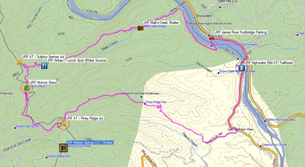


 Hammock –
  for use with Draumr Hammock (30D Double Silicone Coated Ripstop Nylon, Fully taped seams, Reflective guy lines)
 LED Flashlight
 Headlamp (
 (
(
 , 70D model, 12’x10′

 ,
,  .
.