Backpacking, Camping in the Rain, and Trail Cooking in Virginia’s Shenandoah National Park.
FTC Disclosure: This post contains affiliate links, which means I may receive a commission for purchases made through some of my links.
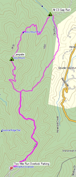
For this overnight backpacking trip, Sara, Denali and I decided to do some early spring camping on the Shenandoah’s Rocky Mount Trail and Gap Run trail. Combining the two would create a roughly 10 mile backpacking loop with sweeping mountain views on the first day, and peaceful babbling brooks on the second.
We had our dog with us on this trip, so we returned to using our budget tent to keep the group together. The weather on day one had a 100% chance of rain, so I also brought along a huge tarp to give us a common area with a view of the impending storm without being stuck inside the tent the whole afternoon. More details on our gear can be found at the bottom of this post.
Off course all of this would depend on whether or not we could find Sara’s elusive secret camping spot before the rain began to really come down…
Shenandoah Rocky Mount Loop – Route Overview – Sintax77
There is an entrance fee for Shenandoah National Park to access Skyline drive. Backcountry camping is free, but you need to self register for a permit at the entrance station. You can find more information on the official SNP website here.
Solo Winter Backpacking & Snow Camping in an attempt to Summit Mount Washington.
FTC Disclosure: This post contains affiliate links, which means I may receive a commission for purchases made through some of my links.
For this adventure, I headed up to the White Mountains of New Hampshire to do some snow camping with the goal of doing of a Mt Washington winter ascent. My plan was to set up a base camp at higher elevation, followed by a lighter weight trek up to the top of Mount Washington.
I went with a tent for shelter on this trip because I originally planned for the possibility of camping above treeline. I had never done that before, but the weather forecast was rather good before I left home, so this seemed like a good opportunity to give it a go. The Presidential Range had other ideas…
No permit is required to backcountry camp in the White Mountain National Forest, but a parking fee is required in some areas.
Trailhead Used: Jewell Trail Trailhead
44°16’01.2″N 71°21’40.7″W
Base Station Rd, Jefferson, NH 03538
This is a large parking lot with room for many vehicles. A parking fee of $5 dollars per day or an annual National Park pass is required.
Join Sara and I for 3 Days of Camp Cooking, Hiking, & Backpacking in the Dolly Sods Wilderness.
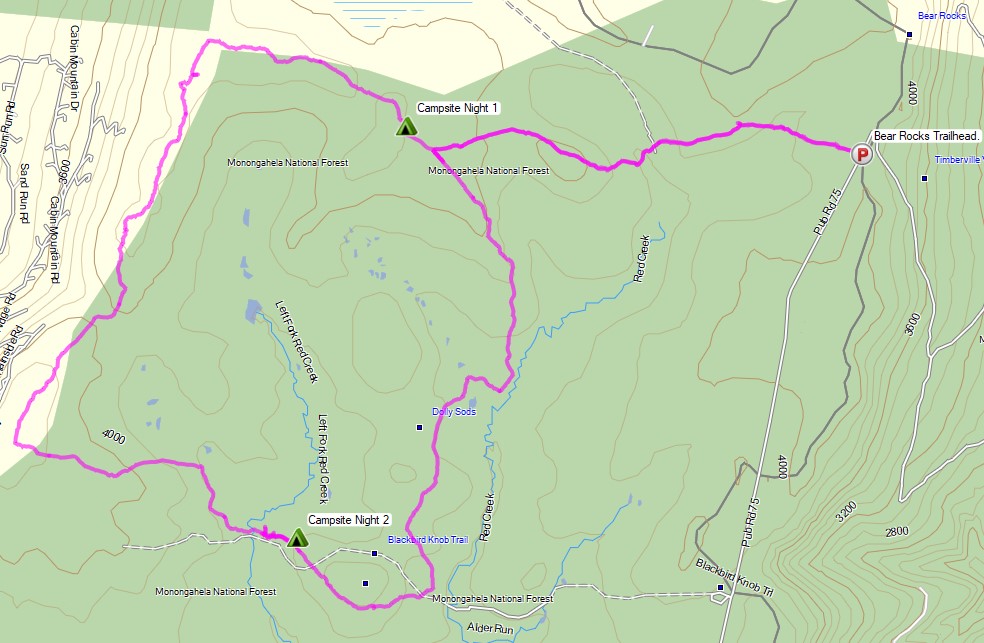
For this 3 day, 2 night backpacking trip, Sara, Denali and I decided to do some fall foliage camping in West Virginia’s Dolly Sods Wilderness, part of the larger Monongahela National Forest. Dolly Sods is located in the Allegheny Mountains on the highest plateau east of the Mississippi river and features some of the most varied and scenic terrain available to hikers in the Mid-Atlantic region.
We had our dog with us on this trip, so we decided to give tent camping a go this time around to keep us all together in one spot. I also decided to totally throw lightweight backpacking out the window for this trip, so I brought along my Fjallraven Kajka 75 backpack and stuffed it to the gills with various backpacking gear, just to have a little fun and switch things up a bit (gear list at end of post). This decision was made easier by the fact that we were starting at Bear Rocks trailhead, which is already high up on the plateau with minimal elevation changes.
Campsites and great views are fairly abundant in Dolly Sods, so our general plan was to keep the mileage low and focus on a relaxed hiking pace, fun backpacking food and camp cooking. It was the perfect recipe for a laid back camping trip. Other than the whole leaking sleeping pad situation to make things more interesting…
Route Overview – Dolly Sods Fall Backpacking Loop – Sintax77
No permit is required to camp in the Dolly Sods Wilderness, but there are rules and regulations regarding backcountry camping. You can find more information on the USFS Dolly Sods website here.
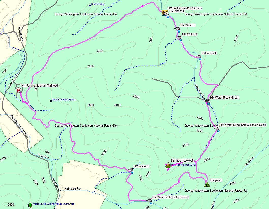
No permit is required to camp in the George Washington National forest, but there are rules and regulations regarding backcountry camping. You can find more information on the George Washington & Jefferson National Forest website here.
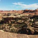
Join Sara and I in Utah for a little high desert camping, hiking, and backpacking in Canyonlands National Park.
For this adventure, we did a 2 day, 1 night backpacking trip through the Needles District of Utah’s Canyonlands National Park, followed by a little day hike visit to Arches National Park on the way back to Salt Lake City to catch our flight back home. In fact, this was actually the first trip we’ve ever done via flight instead our usual road warrior routine. That being said, we still got at least a moderate dose of driving during this trip, as the drive from SLC airport to Moab and Arches NP is about 4 hours. From there it was another 1.5 hour drive south to the Needles District, the southernmost district in Canyonlands.
Full GPS track data and waypoints for this trip can be found on the Trip Data page.
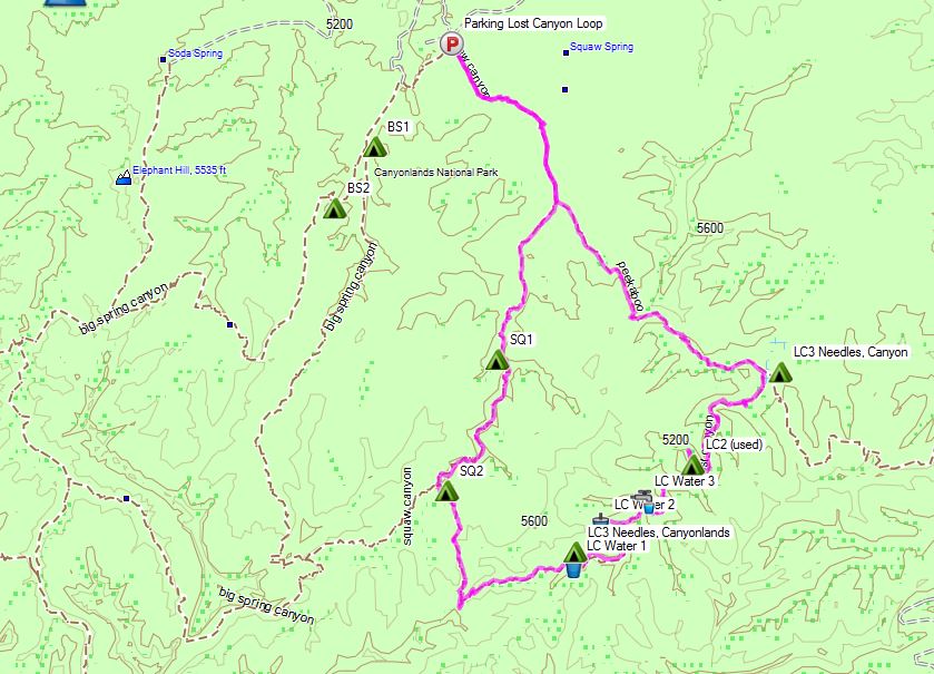
Here’s an overview of the route, highlighted in pink, that we took clockwise. As you can see, there are several other trails accessible from Squaw Flat parking lot, creating the potential for larger loop options.
Squaw Canyon Trail
Lost Canyon Trail
Camp at Lost Canyon Campsite 2 (LC2)
Total Mileage: 6 miles
Gross Elevation Gain: 768′
Gross Elevation Loss: 682′
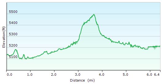
Day 1 Elevation Profile – Lost Canyon Loop
It should be pointed out that campsites in the Needles district are restricted to designated areas only, and must be registered in advance. This can can be done either online or in person at the visitor’s center and costs $30. Since I live about 2,000 miles away, and spots tend fill up well in advance, I went the online route. I reserved my spot about a month in advance and still managed to get the spot I was after, but I could see other areas that were already booked up pretty solid. When stopped in the visitor’s center on the day of our hike in, we caught a glimpse of the availability board and I was hard pressed to see any open spots, so reserving on the same day in person probably isn’t the best game plan. The nice thing is, the spots seem to be nicely spread out. For instance, there were three campsites in the entire Lost Canyon area that we chose to visit, with about a mile of trail in between them. So, while we did have to be a bit more rigid in our planning than usual, and the $30 fee was definitely the highest I’ve ever paid for backcountry permit, we really did feel like we had a whole canyon to ourselves to call home for the afternoon and night. The site was also tucked back a decent way off the main trail and situated with an amazing view. I’m sure all the spots are awesome, but I would highly recommend LC2 to anyone on the fence about where to camp in Canyonlands. It was a great spot.
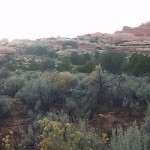
Speaking of things that make a campsite great, Lost canyon was one of the few areas in Canyonlands NP I could find in my research that had a high probability of reliable water. We crossed over several water sources within less that a mile of the campsite, due to the fact that the sites are located in the bottom of a relatively lush canyon within close proximity to the brook that runs though it. It’s quite a stark contrast to the treeless universe or rock, sand and sun lying only a few hundred feet above. It also didn’t hurt that the area experience some decent rains and flash flooding several days before. I tagged a couple of these spots in a GPS file for this trip using my trusty Garmin Oregon 650, but keep in mind that water flow conditions could be much different depending on time of year and amount of recent rainfall. If you’re planning your own adventure, I would definitely suggest more recent reports and / or just bringing enough water for the duration of your stay.
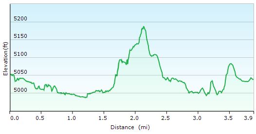
Day 2 Trails Used (In Order)
Lost CanyonTrail
Peekaboo Trail
Squaw Canyon Trail
Return to Squaw Flat Trailhead A and parking lot.
Total Mileage: 3.8 miles
Gross Elevation Gain: 427′
Gross Elevation Loss: 440′
Day 2 Elevation Profile – Lost Canyon Loop
I’ll save the full story for the video, but this was truly an amazing trip! I’ll tell you what though, southern Utah may bitten me and infected me with the desert bug. Hmmmm, where to next…
Stat Totals for the Full 2 Day Loop
Total Mileage: 9.8 miles
Gross Elevation Gain: 1,195′
Post Hike Burger Joint of Choice Moab Brewery
686 S Main St, Moab, UT 84532
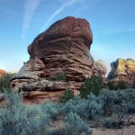
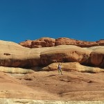
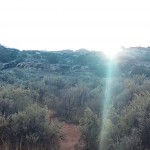
Annnnnd, for good measure, here’s a gallery of some of Sara’s “VR Panorama” and and regular panorama shots that she had fun playing with using her phone’s camera app.
Join us for some frigid winter camping and backpacking along King Ravine in the White Mountains.
For this overnight backpacking trip we’ll be heading up towards Mt Adams, along the Presidential Range in New Hampshire’s White Mountain National Forest in early February. This trip was done almost a year to the day after our High Winds Hiking trip during the previous season. Only instead of temperatures in the 20’s to 30’s, we had a dramatically different temperature range the low teens at it’s warmest, down to roughly 20° below zero at night. Ouch. Luckily, we didn’t have the extreme winds that we encountered on that last February trip. One or the other is one thing. Both together, now that’s what you don’t want.
As you’ll see in the video though, things still didn’t go – how should I say – well, as planned. Thankfully, we were able to make the best of it and play things by ear. While I certainly would have like things to have gone a bit closer to our anticipated itinerary, I think it still ended up be a quite memorable trip. When things go as planned, that’s a vacation. When things go awry and you have to react and adapt, that’s an adventure. And that, after all, is what we’re truly after. As long as know one get hurt, or suffers too much mental trauma, I’ll chalk it up as a win.
Below is a list of trails used, in order, as well parking info and other logistical items. Unfortunately, due to the sub-zero temps, there was no full gps track recorded for this trip. After ripping through two sets of Ultimate Lithiums in my Garmin Oregon 650 GPS on day one, I made the call to reserve my remaining rechargeable batteries for emergency route fining only. On my last winter trip to the Dolly Sods, with temps in the low 20’s, I was able to go the entire 3 day trip on one set of lithium with juice to spare. My performance was quite different at 15 or so below zero, though. Once it warms up a bit, we’ll get back to recording full track data as usual.
Parking Location
Appalachia Trailhead
44.371470, -71.289391
(Not too far from the intersection of US Rt 2 and Dolly Copp Rd, in Gorham NH)
Trails Used Airline Trail to
intersection with Upper Bruin Trail, just above treeline in the Alpine Zone
Planned Campsite: Valley Way Tentsite or nearby vicinity, via Valley Way Trail
Actual Campsite: Back below treeline, along the Airline Trail.
Our plan was to summit Mt Adams the following day and return cheerfully to our previous night’s campsite, base camp style. As seen in the video, things got a bit more complicated, due to extreme snow drifting along King Ravine’s Alpine Zone, heading towards Madison Hut and the intersection with the Appalachian Trail towards Mt. Adams. The plan was to save Adams for day two and to use Upper Bruin Trail to head back below treeline to establish a base camp, after getting some brief views in the ravine above treeline. Despite having been to this area twice before in milder weather, the high snow drifts and unbroken trail made navigation, umm, complicated, to say the least. Add Mike’s little ordeal to the mix, and you’ve got yourself a very interesting little winter camping trip. But I’ll let you find out how all that goes in the actual video…
A Quick Overview of some of the Gear Used
Big Agnes 6p tent (yes, is a car camping tent.) Split three ways.
EMS Longtrail 70 Backpack
MSR Denali Ascent Snowshoes
Kahtoolah MICROspikes (the plan was to feel things out while ascending Mt Adams, and turn back if it felt like crampons were more acceptable)
CAMP Snow Shovel
MSR Rapidfire Stove (Inverted canister stove, no longer produced)
*Mike carried an MSR Whisperlight Universal, rigged for white gas, which we ended up using at night due to the colder temps.
Big Agnes Q-Core SL Sleeping Pad
Hammock Gear Burrow 0 Top Quilt
GSI Halulite Tea Kettle, 32 oz, for snow melting
Vargo 450ml titanium cup
Sea to Summit Alpha Light cutlery set (knife, fork, spoon)
Camera Gear Used
Sony Handycam HDR-cx380, primary cam
GoPro Hero 3, Black edition, secondary cam.
RavPower 10,000 mAH usb battery pack recharger


 , but keep in mind that water flow conditions could be much different depending on time of year and amount of recent rainfall. If you’re planning your own adventure, I would definitely suggest more recent reports and / or just bringing enough water for the duration of your stay.