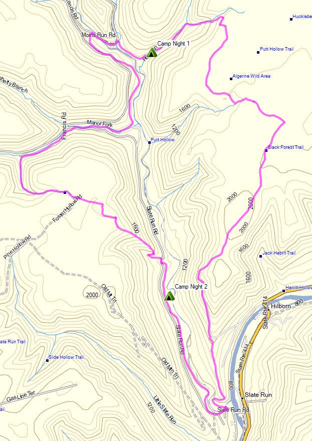
3 days of Backpacking, Thunderstorms & Hammock Camping in Heavy Rain on a section of Pennsylvania’s Black Forest Trail.
For this adventure, I headed out for a 3 day, 2 night solo backpacking trip in Pennsylvania’s Tiadaghton State Forest. The full Black Forest Trail is a rugged 43 mile loop with 8,550′ of elevation gain that I’ve done in the past and really enjoyed.
Facing a July forecast in the triple digits with thunderstorms, and the fact that my last solo hike was a pretty intense one, I decided to scale the mileage back this time. My general plan was to simply go into the woods and use the network of connector trails to come up with a route on the fly, based on how the weather played out from day to day.
Black Forest Trail Short Loop – Route Overview – Sintax77
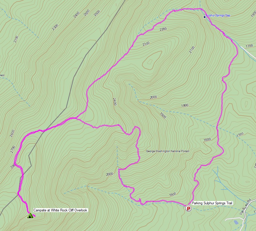
Hiking, Backpacking and an attempt at Tent Camping in the Rain in Virginia’s George Washington National Forest.
FTC Disclosure: This post contains affiliate links, which means I may receive a commission for purchases made through some of my links.
For this overnight backpacking trip, Sara and I decided to do some summer backpacking with our dog on a section of Great North Mountain, a 50 mile long mountain ridge that runs along the border of West Virginia and Virginia.
Despite the threat of a quickly approaching storm, we decided to forge ahead with a modest 3 day, 7 mile backpacking trip. Our plan was to keep the itinerary relatively simple in hopes that we could get to camp in time to beat the rain. And then we ran into a slight complication. Actually, it wasn’t slight at all. It was quite possibly the biggest backpacking mistake I’ve ever made…
White Rock Cliff Loop Virginia – Route Overview – Sintax77
There is no parking fee or backcountry camping permit required for this section of the George Washington and Jefferson National Forest. More details regarding dispersed camping can be found on the official GWJNF website here.
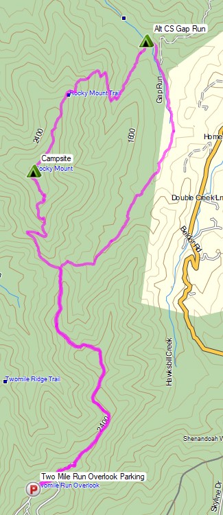
Backpacking, Camping in the Rain, and Trail Cooking in Virginia’s Shenandoah National Park.
FTC Disclosure: This post contains affiliate links, which means I may receive a commission for purchases made through some of my links.
For this overnight backpacking trip, Sara, Denali and I decided to do some early spring camping on the Shenandoah’s Rocky Mount Trail and Gap Run trail. Combining the two would create a roughly 10 mile backpacking loop with sweeping mountain views on the first day, and peaceful babbling brooks on the second.
We had our dog with us on this trip, so we returned to using our budget tent to keep the group together. The weather on day one had a 100% chance of rain, so I also brought along a huge tarp to give us a common area with a view of the impending storm without being stuck inside the tent the whole afternoon. More details on our gear can be found at the bottom of this post.
Off course all of this would depend on whether or not we could find Sara’s elusive secret camping spot before the rain began to really come down…
Shenandoah Rocky Mount Loop – Route Overview – Sintax77
There is an entrance fee for Shenandoah National Park to access Skyline drive. Backcountry camping is free, but you need to self register for a permit at the entrance station. You can find more information on the official SNP website here.
3 days of Hammock Camping in the Rain and Solo Ultralight Backpacking in the Linville Gorge Wilderness.
For this backpacking trip, I headed down to North Carolina’s Pisgah National Forest for some hammock camping along the Linville River. The particular section of river I chose was surrounded by the Linville Gorge, the upper ridges of which stand an average of 1,400 feet above the river banks below. This terrain, combined with a dense network of unofficial trails without signage or switchbacks, and often uncrossable river, can make for some rather challenging and exciting hiking. Add in a forecast of fog and hiking in the rain, and you’ve got yourself a recipe for some true southern outdoors adventure.
Despite the rain, my mid-June temp range for this trip was relatively warm at 70° – 48° or so. This allowed me to get my backpack’s base weight down to around 9 lbs by leaving my puffy jacket, base layers, warmer hat, gloves etc at home. I simply packed a long sleeve shirt and a buff and used my rain gear for supplemental warmth at camp.
I went with a fairly minimalist hammock camping setup for this trip. There are plenty of trees and fun unofficial campsite gems to be found in the Gorge that make ideal for hammocks. Water is obviously of minimal concern for the lower regions of the gorge. This allows you to save some weight on trails in those sections, but make sure to stock up when your route heads up towards the ridge. Especially if you’re looking to camp in one the beautiful ridge side campsites up there. The extra planning and water weight is well worth the views.
A free permit is required on weekends and holidays from May 1st through October 31st each year. You can find more information on the NFS Grandfather Ranger District website here.
If planning your own trip, I would highly recommend visiting LinvilleGorge.net for maps, info and extensive GPS data including official and unofficial trails, campsites, water sources, etc. Due to the nature of my trip and the fact that their data is so darn good, I didn’t package my own GPS file for this trip,but I did make an overlay map image from their track data that can be downloaded here. Just unzip it and copy the image file to your Garmin’s /Garmin folder if you’re using a Garmin GPS like me, or follow whatever instructions pertain to your particular GPS device.
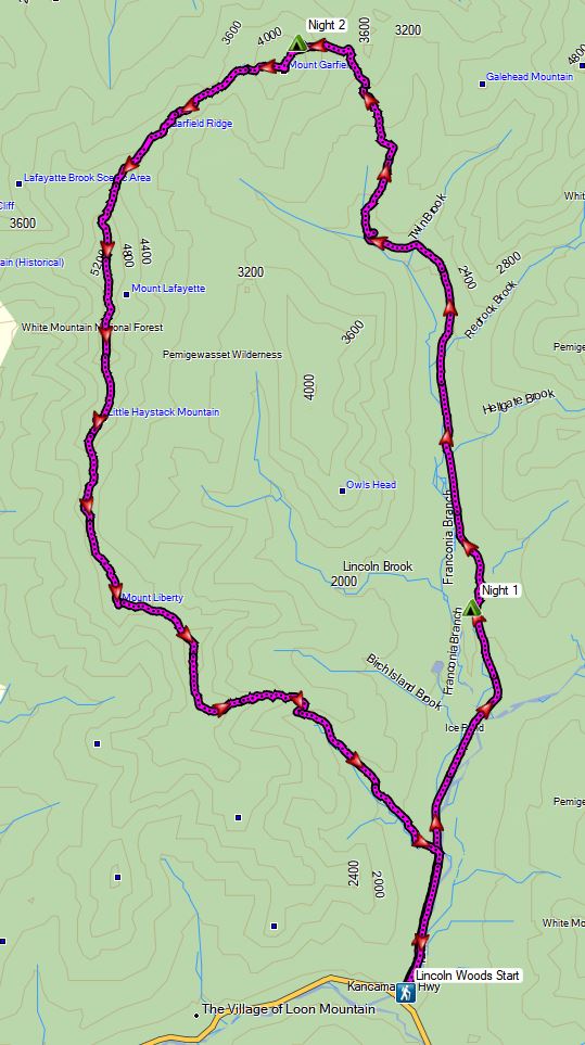
3 Days of Winter Hammock Camping, Backpacking, & Snowshoeing in the White Mountains Pemigewasset Wilderness.
This trip was sponsored by Backcountry, who gave me the opportunity to upgrade three of my essential winter backpacking gear items for this trip. A gear list can be found at the end of this post.
FTC Disclosure: This post contains affiliate links, which means I may receive a commission for purchases made through my links, at no additional cost to you. Individual gear selections were made by me and all opinions are my own.
For this 3 day, 2 night spring winter camping trip, I’ll be hiking what amounts to a sort of “Half Pemi Loop”. While a full pemi loop consists of the Franconia Ridge on one side and the Bondcliff ridge on the other, my plan was to use the lesser used Franconia Brook trail to go straight up the middle of the loop. This would take me above treeline right near the summit of Mt Garfield, with the option to take either the Franconia Ridge to the west, or the Bondcliffs to the east in order to return to the Lincoln Woods visitor center where I had left my Jeep.
Even during “regular” backpacking season, the White Mountains are a quite challenging area to hike due to notoriously rapid changing weather conditions and steep, rugged terrain. Add in some deep snow, ice, rain, high winds and a freeze / thaw temp range of 40° to 16° F, and things can get even more fun. I had a great time, but it was probably the toughest solo winter backpacking trip I’ve ever done.
Winter Half Pemi Route Oveview – Sintax77
No permit is required to camp in the White Mountains NF, but there are rules and regulations regarding backcountry camping. You can find more information on the USFS White Mountains website here. Some parking areas, such as the one I used for this trip, do require a vehicle fee of $5 per day.
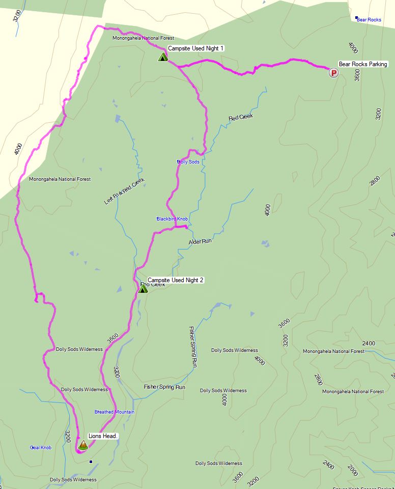
3 Days of Hammock Camping, Hiking, & Backpacking in the Dolly Sods Wilderness.
For this 3 day, 2 night spring backpacking trip, I’ll be hiking a 23 mile loop in West Virginia’s Dolly Sods Wilderness, part of the larger Monongahela National Forest. Dolly Sods is located in the Allegheny Mountains on the highest plateau east of the Mississippi river and features some of the most varied and scenic terrain available to hikers in the Mid-Atlantic region.
For sleep and shelter system on my Dolly Sods backpacking loop, I packed in my Amok Draumr XL hammock, paired with the Amok Borg tarp and Amok Fjol XL sleeping pad. I chose this combo based on plateau’s less aggressive terrain and the extra time I expected to be lounging and relaxing at camp.
No permit is required to camp in the Dolly Sods Wilderness, but there are rules and regulations regarding backcountry camping. You can find more information on the USFS Dolly Sods website here.