Our Best Campsite Yet – Tongue Mountain Backpacking Trip

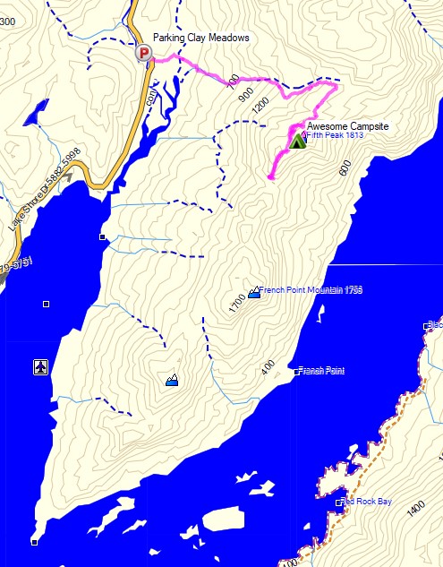
Camping and Backpacking in the Adirondacks on the Tongue Mountain Range.


For this overnight backpacking trip, Sara, Denali and I headed up to New York for some laid back camping on the summit of Fifth Peak Mountain, overlooking Lake George. The Tongue Mountain Range is a 3 mile long peninsula, so named because it looks like a tongue jutting out into the 32 mile long Lake George. Our plan was to hike in a few miles to the top of the range and hit the first peak at the top of the peninsula to set up for an afternoon and night of relaxed camping. The next morning we would have the option to either continue along the 13 mile long Tongue Mountain loop, or hike back out the same way we came in.

We had our dog with us, so we decided to return to tent camping for this trip. We did finally upgrade our previous budget tent to a four person (or 2 plus a dog) Marmot Limelight 4p tent though. And as I usually do for trips with my wife and dog, I packed in a massive backpack full of comfort camping gear and fun camp food. A more detailed gear list can be found at the bottom of this post.

Thank you to Anker for sponsoring this video.  My viewers can get $100 off the Anker Powerhouse II 800 by using this link on Amazon or direct from Anker.

Tongue Mountain Adirondacks - Route Overview - Sintax77
Tongue Mountain Adirondacks – Route Overview – Sintax77

There is no permit required for backcountry camping on the Tongue Mountain Range, but there are certain rules and regulations.  You get find more info on the official NY DEC website here.

Full GPS track data, including campsites, water sources, etc, for this trip and many others can be downloaded on my Trip Data Page.

Continue reading

Camping in the Rain – Sara’s Secret Campsite

Backpacking, Camping in the Rain, and Trail Cooking in Virginia’s Shenandoah National Park.

FTC Disclosure: This post contains affiliate links, which means I may receive a commission for purchases made through some of my links.

For this overnight backpacking trip, Sara, Denali and I decided to do some early spring camping on the Shenandoah’s Rocky Mount Trail and Gap Run trail.  Combining the two would create a roughly 10 mile backpacking loop with sweeping mountain views on the first day, and peaceful babbling brooks on the second.

We had our dog with us on this trip, so we returned to using our budget tent to keep the group together.  The weather on day one had a 100% chance of rain, so I also brought along a huge tarp to give us a common area with a view of the impending storm without being stuck inside the tent the whole afternoon. More details on our gear can be found at the bottom of this post.

Off course all of this would depend on whether or not we could find Sara’s elusive secret camping spot before the rain began to really come down…

Thank you to Private Internet Access for sponsoring this video.  My viewers can get complete digital privacy for less than $3 a month and 3 months free by using this link.

Shenandoah Rocky Mount Loop – Route Overview – Sintax77

There is an entrance fee for Shenandoah National Park to access Skyline drive.  Backcountry camping is free, but you need to self register for a permit at the entrance station.  You can find more information on the official SNP website here.

Full GPS track data, including campsites, water sources, etc, for this trip and many others can be downloaded on my Trip Data Page.

Continue reading

3 Days Hammock Camping with 8 Pounds of Gear

3 days of Hammock Camping & Solo Ultralight Backpacking in Virginia’s George Washington National Forest.

FTC Disclosure: This post contains affiliate links, which means I may receive a commission for purchases made through some of my links.

For this backpacking trip, I headed down to the border of Virginia and West Virginia for some early spring camping to get a dose of some warmer weather, babbling brooks, and mountain views.

With the milder temps and decent forecast, I was able to get my base weight down to 7.75 pounds, a welcome change after hauling some pretty heavy loads my previous few backpacking trips.

For sleep and shelter, I went with my minimalist hammock camping setup consisting of a 10 oz hammock, 5 oz tarp, and a pair 40° down quilts.  The 14 mile Little Schloss Loop has a decent amount of unofficial, but preestablished campsites with some nice  open areas and decently spaced trees, making it a great loop for hammocks. You can find my full backpacking gear list for this trip at the end of this post.

Water is plentiful on the Little Stony Creek side of the loop, but the ridge side of the loop that I started with is dry for the first 5 miles, so I packed in a full load of water for my first day.  Finding water every couple of miles on the remaining two days was no problem at all.

Route Overview – Little Schloss Backpacking Loop – Sintax77

Continue reading

Deep Woods Camping & Finding a Cessna 414

FTC Disclosure: This post contains affiliate links, which means I may receive a commission for purchases made through some of my links.

For this backpacking trip, we hiked into the Cranberry Wilderness in search of a twin engine private plane that crashed in 1995 and went missing for 6 years, deep in the forests of a remote West Virginia mountaintop.  There was also a hiker who went missing here back in 2011.

For sleep and shelter, Frank and I both decided to pack in our Amok Draumr Hammock camping systems. This would allow us to get a comfortable camping setup even if we were forced to camp in one of the mossy rock fields that are often encountered along mountain ridges in the Cranberry Wilderness.  A detailed gear list can be found at the bottom of this post.

On the morning of November 28th, 1995, a Cessna 414, tail number N28901 took off from Braxton County Airport in Sutton, West Virginia headed for Lynchburg Regional, Virginia.  After encountering low visibility due to foggy conditions, the lone pilot contacted air traffic control to request an IFR (instrument flight rules) flight plan in order to continue navigating the approaching mountainous terrain.  After a period of apparent poor communications, possibly due to a radio issue, ATC lost contact with the pilot.  Transponder signals ceased not long after the last communication, and the plane was never heard from or seen again until it was spotted from the air over six years later.

More info on N28901 can be found in this copy of the NTSB report.

Cranberry Wilderness Cessna 414 Search Route Overview - Sintax77

Route Overview – Cranberry Wilderness Cessna 414 Backpacking Trip  – Sintax77

No permit is required to backcountry camp in the Monongahela National Forest.

Full GPS track data, including campsites, etc, for this trip and many others can be downloaded on my Trip Data Page.

Trailhead Used: Big Beechy Trailhead, 38°17’44.2″N 80°14’55.7″W
Highland Scenic Hwy, Minnehaha Springs, WV 24954

Continue reading

Summit Fever – Winter Camping on the Presidential Range

Solo Winter Backpacking & Snow Camping in an attempt to Summit Mount Washington.

FTC Disclosure: This post contains affiliate links, which means I may receive a commission for purchases made through some of my links.

For this adventure, I headed up to the White Mountains of New Hampshire to do some snow camping with the goal of doing of a Mt Washington winter ascent.  My plan was to set up a base camp at higher elevation, followed by a lighter weight trek up to the top of  Mount Washington.

I went with a tent for shelter on this trip because I originally planned for the possibility of camping above treeline.  I had never done that before, but the weather forecast was rather good before I left home, so this seemed like a good opportunity to give it a go.  The Presidential Range had other ideas…

No permit is required to backcountry camp in the White Mountain National Forest, but a parking fee is required in some areas.

Trailhead Used: Jewell Trail Trailhead
44°16’01.2″N 71°21’40.7″W
Base Station Rd, Jefferson, NH 03538

This is a large parking lot with room for many vehicles.  A parking fee of $5 dollars per day or an annual National Park pass is required.

Notable Backpacking Gear

Camera and Nav Gear used for this episode

Snow Storm at Dawn – Winter Camping on North Fork Mountain

Winter Camping in a Snow Storm on North Fork Mountain, West Virginia.

FTC Disclosure: This post contains affiliate links, which means I may receive a commission for purchases made through some of my links.

For this winter backpacking trip, we set out to do some overnight camping in the Monongahela National Forest by an awesome vista known as Chimney Top during the last week of January.  The weather forecast showed the potential for a snow storm to land some time between the first night and the morning of the next day, so we decided to keep our mileage fairly low and laid back. Temperatures were projected to be fairly steady in the low to mid 20’s Fahrenheit.

Our initial climb up to the ridge would require a gross elevation gain of roughly 2,000 feet over the course of two miles.  Once we got to the ridge, we would be afforded with seemingly endless mountain views overlooking the Potomac River, New Creek Mountain, and Dolly Sods in the distance.  After following the ridge for a while we would start to look for campsite opportunities.

Besides the quick elevation gain, our main challenge on this trip would be water.  There is only one semi reliable water source on the entire 25 mile length of the North Fork Trail, and it’s located right around the half way point at 12.5 miles.  We wouldn’t be going that far, so we would have to pack in all of our water for drinking and cooking. If the snow storm had hit prior to our arrival, we would have had the advantage of melting snow. With the ground dry and free of snow upon our arrival, we decided to pack in 1 gallon (4 liters) of water per person.

For shelter, Frank and James went with tent camping in individual tents, while I chose to go with a hammock camping setup.  With this mix of shelters, we hoped to be able to find a decent spot to camp on the ridge with some nice mountain views.

Route Overview – North Fork Mountain Trail Chimney Top – Sintax77

No permit is required to backcountry camp in the Monongahela National Forest.

Full GPS track data, including campsites, etc, for this trip and many others can be downloaded on my Trip Data Page.

Trailhead Used: North Fork Mountain Trailhead, Northern End
38°58’53.0″N 79°13’53.8″W
Smoke Hole Rd, Cabins, WV 26855

Continue reading