50 Miles of Hammock Camping in 3 Days – Backpacking on Cranberry Lake

3 days of Backpacking & Hammock Camping along Cranberry Lake in the Adirondacks

FTC Disclosure: This post contains affiliate links, which means I may receive a commission for purchases made through some of my links.

For this adventure, I decided to do a fall backpacking trip with some higher trail mileage than I’ve been doing lately. Nestled in New York’s Five Pond Wilderness, the Cranberry Lake 50 is a fifty mile loop hike that circumnavigates it’s namesake, and passes by many smaller ponds along the way as well. Most of these smaller ponds have campsites or even a lean-to shelter nearby, which is quite nice.

The CL50 is not really an individual trail, but a collection of trail sections from 12 other trails is the area.  The route is well blazed with blue CL50 plastic discs nailed to trees along the way.  The trails used to make up the CL50 are blazed with similar yellow trail discs, so you will often see both blazes simultaneously.

The Cranberry Lake 50 goes directly through two towns – Wanakena, where I started, and the town of Cranberry Lake.  There’s only about 10 trail miles between them, so neither really poses much logistical value for resupplying, but they are nice towns to stroll through.

I chose to do the loop counter clockwise from Wanakena because the last 10 miles traverse some muddy wet sections due to beaver dams, so I figured it would be best to save that for the last afternoon.

I typically like to hike my backpacking trips on a 3 day, 2 night timeline, so that meant my daily trail mileage had to be around 17 miles or so during the shortened daylight hours of October.  On the upside, this hike is primarily along the perimeter of a lake, with minimal elevation changes, but did I mention that I hadn’t done a high mileage trip in a while? Yeah, the headlamp got a good amount of usage on this one. Let the night hiking begin…

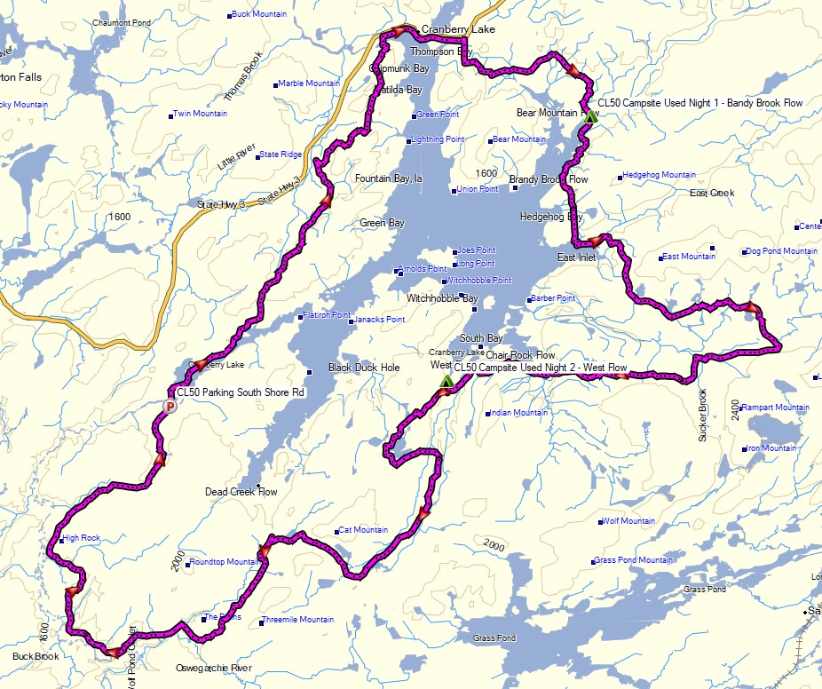
Route Overview – Cranberry Lake 50 Backpacking Loop – Sintax77

Continue reading

Camping with Wild Ponies – Solo Backpacking in the Grayson Highlands

3 days of Solo Backpacking, Hiking & Tent Camping on a section of the Appalachian Trail in Virginia’s Grayson Highlands.

FTC Disclosure: This post contains affiliate links, which means I may receive a commission for purchases made through some of my links.

For this 3 day, 2 night backpacking trip, I headed out for some hiking and solo camping in the Lewis Fork Wilderness and Mt Rogers National Recreation Area, within the larger George Washington and Jefferson National Forest.

With an emphasis on exploring the wild pony grazing areas surrounding Pine Mountain rather than grinding out mileage, I created a modest loop by combining a portion of the Appalachian Trail with the Virginia Highlands Trail. This gave me a super laid route with my campsites for the first and second nights located in the same general area, separated by less than a couple of miles.

I had a backup plan to do a larger 22 mile loop similar to the one I did in this area a few years back, but I knew from that trip that there was a good possibility I would want to slow things down and soak in the sights in this particular area.  Overall, I was very happy with my choice, but keep in mind that there are many more spots to explore if you’re planning your own trip to the Grayson Highlands.  The details of my previous larger loop can be found here if you’re interested.

The Grayson Highlands are known for their high winds and unpredictable, rapidly changing weather, but luckily for me, the mid September forecast called for an ideal temperature range of 55 to 80 degrees. This allowed me to get by on an ultralight backpacking setup with minimal extra clothing and gear.  My shelter for this trip was my Outdoor Vitals 1p tent in “fast and light” mode –  which just means that I left the main tent body with bugnet at home and set it up using only the tent fly, poles and ground cloth.

Thank you to Revtown Jeans for sponsoring this trip video!

Grayson Highlands Backpacking Trip – Route Overview – Sintax77

Trailhead Used: Elk Garden Trailhead Parking,  36°38’46.7″N 81°34’59.0″W
Whitetop Mountain Rd, Troutdale, VA 24378

This is an easily accessible grass and gravel parking area with room for a decent amount of cars. No fee or permit is required for parking or backcountry camping.  There are pit toilets without running water on site.  I began my hike at the gate on the other side of the road.

Full GPS track data, including campsites, etc, for this trip and many others can be downloaded on my Trip Data Page.

Continue reading

Hundred Degree Hammock Camping with Thunderstorms – Black Forest Trail

3 days of Backpacking, Thunderstorms & Hammock Camping in Heavy Rain on a section of Pennsylvania’s Black Forest Trail. 

For this adventure,  I headed out for a 3 day, 2 night solo backpacking trip in Pennsylvania’s Tiadaghton State Forest.  The full Black Forest Trail is a rugged 43 mile loop with 8,550′ of elevation gain that I’ve done in the past and really enjoyed.

Facing a July forecast in the triple digits with thunderstorms, and the fact that my last solo hike was a pretty intense one, I decided to scale the mileage back this time.  My general plan was to simply go into the woods and use the network of connector trails to come up with a route on the fly, based on how the weather played out from day to day.

Black Forest Trail Short Loop – Route Overview – Sintax77

Continue reading

Honey I Forgot the Tent – When Backpacking Goes Wrong

Hiking, Backpacking and an attempt at Tent Camping in the Rain in Virginia’s George Washington National Forest.

FTC Disclosure: This post contains affiliate links, which means I may receive a commission for purchases made through some of my links.

For this overnight backpacking trip, Sara and I decided to do some summer backpacking with our dog on a section of Great North Mountain, a 50 mile long mountain ridge that runs along the border of West Virginia and Virginia.

Despite the threat of a quickly approaching storm, we decided to forge ahead with a modest 3 day, 7 mile backpacking trip. Our plan was to keep the itinerary relatively simple in hopes that we could get to camp in time to beat the rain. And then we ran into a slight complication. Actually, it wasn’t slight at all. It was quite possibly the biggest backpacking mistake I’ve ever made…

White Rock Cliff Loop Virginia – Route Overview – Sintax77

There is no parking fee or backcountry camping permit required for this section of the George Washington and Jefferson National Forest.  More details regarding dispersed camping can be found on the official GWJNF website here.

Full GPS track data, including campsites, water sources, etc, for this trip and many others can be downloaded on my Trip Data Page.

This trip video was sponsored by RevolutionRace. Use code 15sintax to get 15% off their entire Amazon store site until 9/11/21 here.

Trailhead Used: Sulphur Springs Parking Area Forest Road 1725
38°58’31.4″N 78°34’03.5″W
FR1725, Maurertown, VA 22644

Continue reading

Hammock Camping on the Six Husbands Trail

Hammock Camping and Solo Backpacking in the White Mountains of New Hampshire

FTC Disclosure: This post contains affiliate links, which means I may receive a commission for purchases made through some of my links.

For this adventure, I decided to get back to my ultralight backpacking roots with a rugged 27 mile loop through the Great Gulf Wilderness, Dry River Wilderness, and Presidential Range, with a gross elevation gain of around 8,400 feet. The centerpiece of my loop would be the Six Husbands Trail, a trail that some say is the most difficult in the White Mountain National Forest. Now , if you’re familiar with the WMNF, you probably know that just about every trail is pretty intense, so this could get interesting…

For sleep and shelter, I went with my standard minimalist hammock camping setup consisting of a 10 oz hammock, 5 oz tarp, and a pair of 40° down quilts.  This got my base weight down to around 7 lbs. A full gear list can be found at the bottom of this post.

The Six Husbands Trail was Built from 1909 to 1910 by trail builder Warren W. Hart of the Appalachian Mountain club. Hart was known to build his trails specifically with adventure in mind, and this trail was no exception. It begins deep in the Great Gulf Wilderness at the junction with Wamsutta Trail, which along with the connected Alpine Garden trail is actually just the renamed southern portion of the Six Husbands trail. Wamsutta was one the six husbands of female Indian Chief, Weetamoo, who has a nearby waterfall named after her.

White Mountains Six Husbands Backpacking Loop – Route Overview – Sintax77

Continue reading

Our Best Campsite Yet – Tongue Mountain Backpacking Trip

Camping and Backpacking in the Adirondacks on the Tongue Mountain Range.


For this overnight backpacking trip, Sara, Denali and I headed up to New York for some laid back camping on the summit of Fifth Peak Mountain, overlooking Lake George. The Tongue Mountain Range is a 3 mile long peninsula, so named because it looks like a tongue jutting out into the 32 mile long Lake George. Our plan was to hike in a few miles to the top of the range and hit the first peak at the top of the peninsula to set up for an afternoon and night of relaxed camping. The next morning we would have the option to either continue along the 13 mile long Tongue Mountain loop, or hike back out the same way we came in.

We had our dog with us, so we decided to return to tent camping for this trip. We did finally upgrade our previous budget tent to a four person (or 2 plus a dog) Marmot Limelight 4p tent though. And as I usually do for trips with my wife and dog, I packed in a massive backpack full of comfort camping gear and fun camp food. A more detailed gear list can be found at the bottom of this post.

Thank you to Anker for sponsoring this video.  My viewers can get $100 off the Anker Powerhouse II 800 by using this link on Amazon or direct from Anker.

Tongue Mountain Adirondacks - Route Overview - Sintax77
Tongue Mountain Adirondacks – Route Overview – Sintax77

There is no permit required for backcountry camping on the Tongue Mountain Range, but there are certain rules and regulations.  You get find more info on the official NY DEC website here.

Full GPS track data, including campsites, water sources, etc, for this trip and many others can be downloaded on my Trip Data Page.

Continue reading