Facing the Elements: Joshua Tree Backpacking in a Rain Storm

Join me for 3 days of Backpacking, Hiking and Desert Camping in the Rain while  exploring California’s Joshua Tree National Park.

For this winter desert camping adventure, I decided to do a solo backpacking trip in Southern California’s Joshua Tree National Park.  I chose the Maze zone as my primary area of exploration, with the added possibility of hiking along the storied Boy Scout Trail as well.

Due to backcountry camping permit regulations, I chose to obtain a permit for camping within the Maze Zone, with the possibility of hiking into and exploring the Boy Scout Zone by day.  This was mostly due to the fact that the Boy Scout Zone is the only JNP zone that requires you to specifically get a permit for 1 of 8 specific campsites, and I wanted to have some more flexibility to choose my campsites on the fly.

Getting a permit for the Maze zone allowed me to camp anywhere I wanted as long as I was at least 1 mile from an official trailhead, one half mile from any road, and 200 feet from any trail.  Prefect – that sounded like exactly the solitude I was looking for.

Being February in the Mojave Desert, my expected temperature range would be from roughly 40 to 75 degrees or so.  What about rain, you ask?  Well, 336 days out of the year, the answer would be a solid – “No need for rain gear over here!”.  I apparently arrived on one of those 29 other days.  No worries though. I think it provided a pretty unique opportunity to see the Mojave Desert during one of it’s most vital times for survival of plants and animals in this arid environment – a desert rain storm curtesy of El Niño.

For sleep and shelter, I packed in my Outdoor Vitals Fortius trekking pole tent, a 3-season sleeping pad and my Hammock Gear 40° down quilt.  Reliable drinking water is pretty much non-existent in Joshua Tree National Park regardless of the season, so I was tasked with packing in all of my drinking water for the entire 3 day trip.  For this reason, I decided to skip the usual dehydrated backpacking meal choices in favor of some cheap and easy ready to eat food options.

I also opted to ditch the stove and just go the no-cook backpacking food route, because why not?   Honestly, my pack was jammed to the hilt with water, and I just wasn’t in the mood to carry more fuel and cooking supplies.

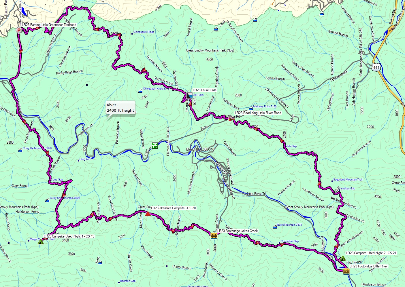
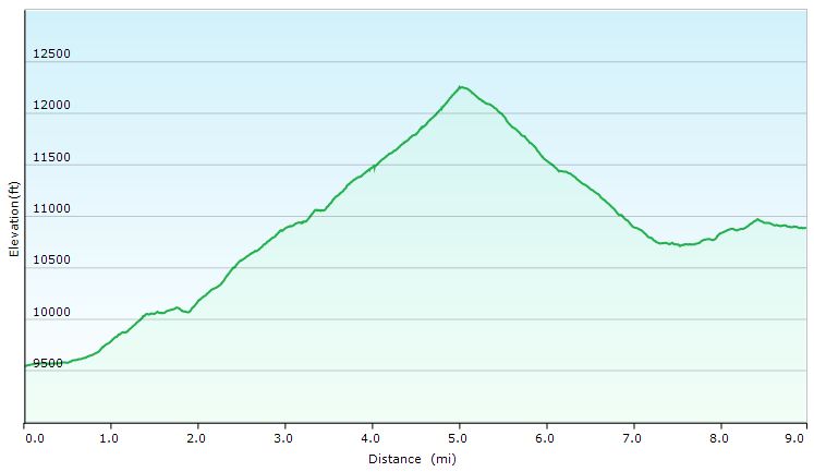
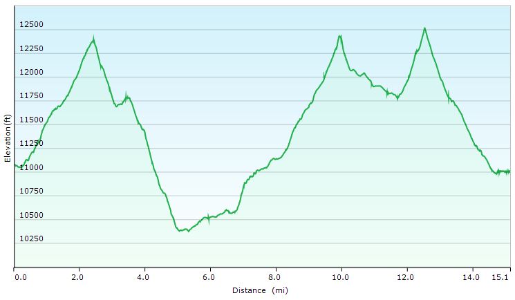
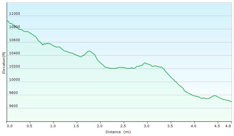
Route Overview – Smoky Mountains Little River Gorge Backpacking Loop – Sintax77

A permit is required for backcountry camping in Joshua Tree National Park.  You can reserve them on the Joshua Tree National Park website here.

Full GPS track data, including campsites, water sources, etc, for this trip and many others can be downloaded on my Trip Data Page.

Continue reading

Our Best Campsite Yet – Tongue Mountain Backpacking Trip

Camping and Backpacking in the Adirondacks on the Tongue Mountain Range.


For this overnight backpacking trip, Sara, Denali and I headed up to New York for some laid back camping on the summit of Fifth Peak Mountain, overlooking Lake George. The Tongue Mountain Range is a 3 mile long peninsula, so named because it looks like a tongue jutting out into the 32 mile long Lake George. Our plan was to hike in a few miles to the top of the range and hit the first peak at the top of the peninsula to set up for an afternoon and night of relaxed camping. The next morning we would have the option to either continue along the 13 mile long Tongue Mountain loop, or hike back out the same way we came in.

We had our dog with us, so we decided to return to tent camping for this trip. We did finally upgrade our previous budget tent to a four person (or 2 plus a dog) Marmot Limelight 4p tent though. And as I usually do for trips with my wife and dog, I packed in a massive backpack full of comfort camping gear and fun camp food. A more detailed gear list can be found at the bottom of this post.

Thank you to Anker for sponsoring this video.  My viewers can get $100 off the Anker Powerhouse II 800 by using this link on Amazon or direct from Anker.

Tongue Mountain Adirondacks - Route Overview - Sintax77
Tongue Mountain Adirondacks – Route Overview – Sintax77

There is no permit required for backcountry camping on the Tongue Mountain Range, but there are certain rules and regulations.  You get find more info on the official NY DEC website here.

Full GPS track data, including campsites, water sources, etc, for this trip and many others can be downloaded on my Trip Data Page.

Continue reading

Backpacking the Devils Path – Most Dangerous Hiking Trail?

Some say it’s the Toughest, most Dangerous Hiking Trail in the east. We set out on a backpacking trip to find out how tough the Devil’s Path trail really is.


Set in New York’s Catskill Mountains, the Devil’s Path is a 24.6 mile long end to end hike on steep, rocky terrain with around 8,500 feet of elevation gain and and 9,000 feet of elevation loss.

The mountain range that the Devil’s Path traverses is basically one large plateau with a handful of deep notches carved into it. The result? Almost all of the elevation change is crammed into a handful of 1 mile or less stretches, with little to no distance in between each ascent and descent.  Scrambles, loose rock and mazes of gnarly roots add to the challenge.

Myself, Kyle from the Trail Tails Podcast and Flossy packed up our backpacks with some tents and hammocks and hit the trail on a mid-August morning to find out if this hiking trail would live up to it’s devilish reputation.

Catskills Devil’s Path Route Overview – Sintax77

There are 5 Major Summits (Catskill 35ers) on this hike

  • Indian Head Mountain 3,573′
  • Twin Mountain 3,652′
  • Sugar Loaf Mountain 3,806′
  • Plateau Mountain 3,840′
  • West Kill Mountain 3,880′

Starting Trailhead Used (East): Platcove Trailhead , 42°08’02.5″N 74°06’16.1″W
Prediger Trail Road, Elka Park, NY 12427

This is an easily accessible parking lot with room for a decent amount of cars, but it does reportedly fill up by early morning on weekends.

Continue reading

Hiking the Ultimate White Mountains Backpacking Loop

3 Days of Hammock Camping, Hiking & Backpacking on the White Mountains Presicat Loop.

For this 3 day, 2 night summer backpacking trip, I’ll be hiking a 30 mile backpacking loop in New Hampshire’s White Mountain National Forest.  I call this the Presicat loop because it’s comprised of the Carter Range and Wildcat Range on one side, and the northern section of the Presidential Range on the other.

This route creates a grand tour of the northern White Mountains with a section of the Appalachian Trail and Mt Washington as it’s centerpiece.  Along the way we’ll hit 9 major summits (NH48’s) and 8 subsidiary peaks, while racking up 15,228 feet of elevation gain on some pretty rugged trails.

For sleep and shelter I chose a minimalist ultralight hammock camping system. This allowed me to get my base weight down to 9 lb.  Notable gear can be found in the gear section below. Or check out my full printable list with weights and links on LighterPack.

Presicat Loop Route Overview 2019 – Sintax77

No permit is required to camp in the White Mountains, but the trailhead I chose did require a self payment of $3 per day. Rules and regulations regarding backcountry camping can be found on the USFS website here.

Full GPS track data, including campsites, water sources, etc, for this trip and many others can be downloaded on my Trip Data Page.

Continue reading

Hammock Camping the Dolly Sods Wilderness – Solo Backpacking Trip

3 Days of Hammock Camping, Hiking, & Backpacking in the Dolly Sods  Wilderness.

For this 3 day, 2 night spring backpacking trip, I’ll be hiking a 23 mile loop in West Virginia’s Dolly Sods Wilderness, part of the larger Monongahela National Forest. Dolly Sods is located in the Allegheny Mountains on the highest plateau east of the Mississippi river and features some of the most varied and scenic terrain available to hikers in the Mid-Atlantic region.

For sleep and shelter system on my Dolly Sods backpacking loop, I packed in my Amok Draumr XL hammock, paired with the Amok Borg tarp and Amok Fjol XL sleeping pad.  I chose this combo based on plateau’s less aggressive terrain and the extra time I expected to be lounging and relaxing at camp.

No permit is required to camp in the Dolly Sods Wilderness, but there are rules and regulations regarding backcountry camping. You can find more information on the USFS Dolly Sods website here.

Full GPS track data, including campsites, water sources, etc, for this trip and many others can be downloaded on my Trip Data Page.

Continue reading

Maroon Bells Pt 2 – The Hike! – Backpacking in Colorado

Join Mike & I on Colorado’s Four Pass Loop for 3 days of hiking, backpacking & hammock camping.

For this multi-part adventure, we’ll be faced with two challenges.

Phase 1 (seen in the prior Pt 1 video): Driving on a substantial time crunch from the east coast to Colorado, without any hotels or road food purchases.  This will not only keep the budget low, but will also save us a ton of time by not having to check-in/out, be tempted to sleep in, decide where/what to eat, stand in lines etc.  Sleeping will be done in the car (while the other person drives) and all meals will be comprised of cooler-stored left-overs and pre-purchased beverages.  The only stops allowed: bathroom breaks and gas pumps.

Phase 2 (covered in this video, Pt 2) will be a multi-day hike of the Four Pass Loop, within the Maroon Bells Snowmass Wilderness, located just outside of Aspen Colorado (about 3 hours west of Denver).  We chose to do the loop in a counter-clockwise direction.

Trailhead Used: Maroon Bells Snowmass Wilderness Trailhead N39° 05.979′ W106° 56.260′

Full GPS track data and waypoints for various POI’s on this trip are available for download on the Trip Data Page.

Trails Used, Day 1 (in order)
Maroon Snowmass Trail
Camp near Snowmass Lake

Maroon Bells Day 1 Elevation Profile - Sintax77

Maroon Bells Day 1 Elevation Profile – Sintax77

Day 1 Mileage: 9 miles
Day 1 Gross Elevation Gain: 3,202′

Trails Used, Day 2 (in order)
Geneva Lake Trail
North Fork Cutoff Trail
North Fork Trail
West Maroon Pass Trail
Camp near West Maroon Pass Trail

Maroon Bells Day 2 Elevation Profile - Sintax77

Maroon Bells Day 2 Elevation Profile – Sintax77

Day 2 Mileage: 15 miles
Day 2 Gross Elevation Gain: 4,488′

Trails Used, Day 3 (in order)
West Maroon Pass Trail
Maroon Snowmass Trail
Return to vehicle at Maroon Snowmass Trailhead

Maroon Bells Day 3 Elevation Profile - Sintax77

Maroon Bells Day 3 Elevation Profile – Sintax77

Day 3 Mileage: 4.8
Day 3 Gross Elevation Gain: 305′


Mileage Grand Total for Trip: 28.8
Gross Elevation Gain Grand Total for Trip: 7,995′